Gunnels: Difference between revisions
No edit summary |
No edit summary |
||
| Line 1: | Line 1: | ||
[[Category:Campus]] | |||
The '''Gunnels''', or '''Gunn Tunnels''', are a pair of culverts forming the Barron Creek Bypass Structure. They are walkable during the dry season and have for years been a popular location for Gunn students to "hang out". Graffiti covers most of the tunnel walls and large parts of the floors. | The '''Gunnels''', or '''Gunn Tunnels''', are a pair of culverts forming the Barron Creek Bypass Structure. They are walkable during the dry season and have for years been a popular location for Gunn students to "hang out". Graffiti covers most of the tunnel walls and large parts of the floors. | ||
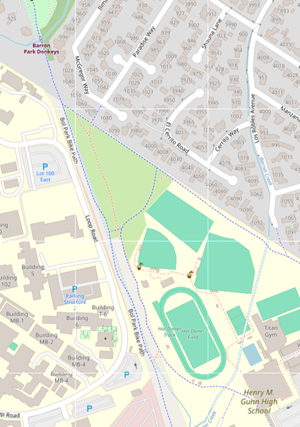
[[File:Screenshot 2024-10-24 7.50.27 PM.png|thumb|The Gunnnels (double dotted blue lines) run northwest from Barron Creek to Matadero Creek.]] | [[File:Screenshot 2024-10-24 7.50.27 PM.png|thumb|The Gunnnels (double dotted blue lines) run northwest from Barron Creek to Matadero Creek.]] | ||
Revision as of 17:09, 6 January 2025
The Gunnels, or Gunn Tunnels, are a pair of culverts forming the Barron Creek Bypass Structure. They are walkable during the dry season and have for years been a popular location for Gunn students to "hang out". Graffiti covers most of the tunnel walls and large parts of the floors.

The tunnels are visible on OpenStreetMap but not Google Maps. You can view them at this link.
Barron Creek
Barron Creek begins in the foothills and runs north, meeting Gunn High School. From there it enters a debris basin (a basin to capture debris and prevent it from going downstream) and flows through a pipe under Los Robles Avenue, emerging at El Camino. It continues north until it empties, along with Adobe Creek into the Palo Alto Flood Basin. The flood basin is connected to the San Francisco Bay through a tide gate, which allows water to flow out, but not into the flood basin, ensuring its water levels remain low to prevent flooding.[1][2]
To resolve the problem of frequent flooding during winter storms, the Gunnels (officially known as the Barron Creek Bypass) were constructed to divert water to Matadero Creek in times of heavy rain. The bypass (now called the Matadero Bypass) continues past Matadero Creek, meets the Stanford Channel (an artificial channel which brings water from Santa Rita Creek) at Matadero Avenue, and reunites with Matadero Creek at El Camino Real.[3][4]
Entrances
The two main entrances to the Gunnel used by students are at the debris basin and at Matadero Creek, just beyond the Barron Park Donkeys. Both are sealed by a grate which has been pried open.
- ↑ https://scvurppp.org/watersheds/santa-clara-basin-watersheds/barron-watershed/
- ↑ https://explore.museumca.org/creeks/1440-OMAdobe.html#
- ↑ https://www.valleywater.org/sites/default/files/PAFB%20Hydrology%20Corrected%20Final%20Report%20%28July%202016%29.pdf
- ↑ https://explore.museumca.org/creeks/1450-OMMatadero.html#